
America’s Troubled Waters: Can They be Saved?
Peter Lourie, a chronicler of river life, says that rivers are living mysteries, linking the past to the future. Today, that link has been largely broken. Through damming, dredging and channelization, we have changed the way rivers flow—diverting water to generate hydropower, support navigation and irrigate crops. Half of our drinking water still comes from rivers, yet non-point source pollution poses an ongoing threat.

“A lot of things were done before it was understood how important rivers are to our environment,” says Rebecca Wodder, president of the conservation organization American Rivers. “The United States leads the world in diversity of freshwater creatures. Yet these same species are equally as endangered as those in tropical rainforests.” (So far, 17 species of freshwater fish have gone extinct.)
At the same time, restoration of healthy rivers has climbed high on many local agendas, resulting in some 4,000 river-oriented grassroots groups around the country. Riverkeepers and Waterkeepers patrol in search of pollution violators, and even government entities such as the Army Corps of Engineers have begun to think twice about altering nature’s course.
Robert Kennedy, Jr., president of the Waterkeeper Alliance, warns of hard struggles ahead: “The Supreme Court recently dealt the biggest blow to the Clean Water Act in its 30-year history, lifting the protection of hundreds of millions of acres of wetlands and opening them up to developers with the stroke of a pen.” President Bush’s new Environmental Protection Agency (EPA) chief, former New Jersey Governor Christine Todd Whitman, “saw environmental regulation as an impediment to business,” notes Kennedy. He calls her “a disaster for the Hudson River and New Jersey waterways.” He also points out that Bush’s Interior Secretary, Gale Norton, has argued that the Surface Mining Act, which protects Western streams from pollution, is unconstitutional. “Those are bad omens,” Kennedy concluded in an interview with E, “for people who care about America’s waterways.”
Each year, Washington, D.C.-based American Rivers profiles the nation’s 13 most endangered rivers to call attention to imminent threats as well as opportunities for change. Spotlighting these rivers with policy-makers and the public has brought results. The Yellowstone’s Clark Fork, for example, topped the endangered list from 1994 to 1996; President Clinton, in August 1997, had the government buy out the gold mine threatening it. The Hanford Reach of the Columbia River, No. 1 in 1998, was declared a national monument by Clinton in July 2000.
A central theme of this year’s listing is energy. “Large segments of both the development and production side of energy have a significant impact on rivers and wildlife,” says the group’s energy policy director, Andrew Fahlund.
The lineup of America’s Most Endangered Rivers, 2001, in descending order of threat, looks like this:
1. The Missouri
When first traversed by Lewis and Clark during their 1804 expedition, this was surely America’s most dynamic waterway. It came to be called the “Big Muddy,” an ever-shifting combination of multiple side channels, sandbars and islands. Beginning in Montana and running for 2,500 miles before joining the Mississippi just north of St. Louis, the Missouri drains about one-sixth of the surface area in the contiguous U.S., covering some 530,000 square miles.
Today, however, the river might more aptly be called the “Big Boondoggle.” Shortly after World War II, most of the river’s natural character was altered by dams and channels to create a deep, rock-lined barge canal and a series of slack water reservoirs. The average width of the “wide Missouri,” sung about in the song “Shenandoah,” has been reduced by two-thirds, and below Sioux City, Iowa, it’s been shortened by 127 miles. In the Dakotas and eastern Montana, most of the original Missouri has been buried under America’s largest reservoirs.

It was predicted that the Missouri would carry 20 million tons of cargo a year, but the economic benefits anticipated from increased navigation never materialized. Barge traffic peaked at 3.3 million tons in 1977 and now has fallen to less than 1.5 million tons. Farmers simply have easier access to trains and trucks for transporting their grain. The Army Corps of Engineers spends more money maintaining the navigation channels (more than $7 million annually) than the cargo revenues bring in.
By altering flows, the Missouri’s dam operations have also gotten rid of sandbar nesting areas for least terns and piping plovers, and spawning areas for the pallid sturgeon—all three on the Endangered Species List. Riverbank cottonwoods once provided roosting for bald eagles, but because of a lack of flood-renewed soil and uncontrolled livestock, they’ve declined.
Still, as the renowned author and American Rivers board member Stephen Ambrose puts it: “Though few rivers have been subjected to human influence as much as the Missouri, no river possesses more potential for revitalization.” In one of his final acts as President, Clinton designated the Missouri Breaks portion in Montana as a National Monument, helping preserve the river’s least-altered portion—provided that the incoming Bush Administration gives the Bureau of Land Management enough funding to properly manage riverside grazing and recreation.
And dam reforms are finally under consideration. In early February, the Army Corps and U.S. Fish and Wildlife Service (USFWS) concluded that opening dams in the spring might avert species extinction. Reducing summer releases, also proposed, would temporarily suspend commercial navigation on the lower river but benefit reservoir recreation—an $87 million-a-year business. “This opinion,” says Chad Smith of the American Rivers field office in Nebraska, “clearly lays out what needs to be changed on the Missouri.” The Corps subsequently decided to delay these reforms until 2003.
2. The Canning
From its emerald-green headwaters, the swift-flowing Canning River eventually crosses four northeastern Alaskan mountain ranges on its way to the Arctic Ocean. It is the longest north-flowing of the 18 major rivers within the Arctic National Wildlife Refuge (ANWR)—America’s largest such designated area. Passing by raft or canoe beneath numerous cliffs, visitors might glimpse peregrine falcons, rough-legged hawks or four species of loons, or they might pause to fish for the tasty Arctic grayling and Dolly Varden (arctic char). One section of the river was named after the numerous musk ox grazing along its banks. The Canning and its Marsh Fork form the western border of a coastal plain that is a calving ground for nearly 130,000 Porcupine Caribou, the second-largest such herd in Alaska.

However, that same yet-untouched coastal plain is believed to contain the best prospects for the ANWR oil that the new Bush Administration is eagerly looking to exploit. It stretches across 1.5 million acres, a 20- to 40-mile band between the foothills of the Brooks Range and the Beaufort Sea, and it contains the only stretch of U.S. Arctic coastline currently not open for drilling. Should this change, the Canning would be the first river impacted.
And those impacts could be monumental. Consider the massive water withdrawals needed for injection into pumps: as much as 15 million gallons of water to pump a single exploratory well. About nine million gallons are available in the entire coastal plain during winter, so the drilling will eliminate critical supplies, killing overwintering fish like the Arctic grayling that survive under the ice. Oil companies would likely end up excavating water reservoirs.
Considerable gravel would be removed for construction. The river would become a major transportation route, bringing in equipment and transferring the oil, pipelines, bridges and roads that will be constructed across it. Noise from seismic activity will afflict the riparian wildlife, whose “high species diversity” is considered unique. Not to mention the most obvious risk—a catastrophic oil spill. All this in an area the U.S. Geological Survey estimates probably holds only a six-month supply of oil.
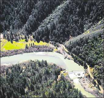
3. The Eel
Spilling out of the cauldron of an ancient volcano in the southernmost reaches of the Mendocino National Forest, the Eel River flows mostly north for about 150 miles through some of California’s most beautiful redwood groves before emptying into the Pacific. Its watershed is the third largest in the state, covering 3,684 square miles. Its year-round fishing was about as good as it gets—until three prime species ended up listed under the Endangered Species Act (coho salmon, chinook salmon and steelhead).
That’s when the Potter Valley Hydropower Project came to the headwaters of the Eel. While the project generates a small amount of electricity, its main purpose is to transfer water from the Eel into the Potter Valley and then to the adjacent headwaters of the south-flowing Russian River. There, two dams capture and store Eel River water and deliver it to the Russian’s East Fork, where it rapidly diverts into irrigation ditches to serve agricultural interests (primarily grape growers), or it is used for industrial and municipal water supply demands of the Potter Valley.
Currently, as much as 98 percent of the Upper Eel River’s summer flows are “lost” to the Russian River system. The Federal Energy Regulatory Commission’s flow schedules were identified by the National Marine Fisheries Service (NMFS) as having significant impacts on steelhead migration, spawning and rearing habitats. Additionally, the uppermost Scott Dam isn’t equipped with a fish ladder, forming a barrier blocking more upstream habitat.
Meanwhile, California’s deregulation of its utility industry threatens to further impact the Eel—depending on which new owners acquire the Potter Valley Project. A recent environmental report by the California Public Utilities Commission indicates that if that facility is operated to maximize power generation or water supply, there will be even greater impacts on the river’s endangered fisheries.
4. The Hudson
Rip Van Winkle’s river, a setting for landscape painters for more than two centuries, flows through 315 miles of mountains, dense forests, wetlands, occasional low islands and extensive tidal flats. Ten million residents of New York live within a half-mile of the Hudson, and tourism generates $3 billion in annual revenues. Among the river’s more than 200 varieties of fish are such species as the striped bass, Atlantic sturgeon and American shad, all of which utilize it as a spawning ground.

Largely unfishable and unswimmable due to years of neglect until the 1970s, the Hudson then became a focus of activism and has since been partially restored to its former grandeur. The biggest continuing threat dates back to the late 1940s, when General Electric began 30 years of discharging an estimated 1.3 million pounds of PCBs into the river from its capacitor plants. Outlawed in 1977, PCBs migrate downriver to settle in the sediment of slow-moving pools, or wash downstream with the current. The toxics concentrate in fish, posing health risks to consumers who eat them. Also at risk from PCB exposure are the great blue herons, river otters, mink and other animals that eat contaminated fish or plants.

In December 2000, after a 10-year battle between G.E. and the federal government, the EPA ordered the company to spend $500 million over five years to dredge PCBs embedded in the river bottom north of Albany. The plan calls for removing 2.6 million cubic yards of sediment that hold about 100,000 pounds of PCBs, dredging this from 33 “hot spots” along a 40-mile stretch of the river.

For its part, G.E. asserts that it’s better to leave the PCBs undisturbed where they lie. The company has also maintained that the old Allen Mill, whose gate failed in 1991 and released a reservoir of PCBs and other materials into the Hudson, is more to blame for the ongoing pollution problems than the poisoned sediments. After a period of public comment, a final order on the cleanup plan is anticipated by June.
5. The Powder
This river basin is northeast Wyoming’s corner of the Great Plains, a healthy remnant of the vast ecosystem that once spanned them. The Powder and its four tributaries host a remarkable variety of wildlife: eagles, falcons, pronghorn antelope, white-tailed deer, mountain lions and one of the last herds of plains elk. It’s also essential habitat for the imperiled sage grouse, mountain plover and black-tailed prairie dog. And it’s the last stronghold for 25 native fish species, including the rare shovelnose sturgeon, the sturgeon chub and the western silvery minnow.
On these same arid high plains, the Powder River Basin produces one-fifth of all the coal in the U.S. The Powder River Coal Company, America’s second largest, owns and operates four surface mines controlling 2.5 billion tons of recoverable coal. Because of its relatively low sulfur content, which leads to less acid rain, Powder River coal is in demand by electric power companies.
What has really turned the little hamlet of Gillette, Wyoming, into a boomtown, though, is coalbed methane gas. Locked in the coal seams just below the surface, the gas is less expensive to mine than natural gas found in
other geological formations. In order to release the methane, however, enormous volumes of water—nearly 15,000 gallons per day per well—are discharged into arroyos or reservoirs, causing soil erosion, stream sedimentation, death of vegetation and generally degraded water quality.
Since coalbed methane production started in 1987, 21 billion gallons of water have been extracted by only 2,670 wells—an average of nearly eight million gallons per well. The Bureau of Land Management has predicted that the number of wells could grow to as many as 35,000 within the next decade. This means the Powder River Basin’s soils, arroyos and streams will receive an astounding one billion gallons of water per day. Wyoming has yet to conduct studies on the impact to aquatic organisms and the stream ecosystems on which they depend.
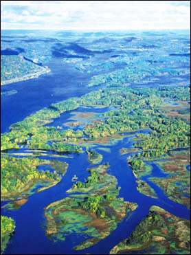
6. The Mississippi and Tributaries
The mighty Mississippi of Mark Twain, more than 2,350 miles long, encompasses 30 states and two Canadian provinces. More than 18 million people rely upon the river for their daily water supply. Forty percent of America’s migratory waterfowl use the Mississippi’s corridor for their flyway, and the river sustains more than five million acres of forested wetlands.
It also provides the Gulf of Mexico with 90 percent of its fresh water—discharging, on average, 612,000 cubic feet per second. The polluted runoff of excess nutrients emptying into the river basin is the cause of a 5,000-mile “dead zone” of low oxygen that no longer supports marine life.
A long-term remedy implemented by the Clinton Administration calls for increased aid to farmers along the river and for conservation measures such as buffer strips. But this only begins to address the problems facing the Mississippi, the most polluted waterway in the country (more than 57 million pounds of toxic chemicals were discharged in 1997, the last year for which data are available). The Army Corps of Engineers not only altered a feasibility study in order to justify additional barge traffic on the Upper Mississippi, but also is pushing an agricultural drainage project, known as Yazoo Pumps/Big Sunflower, which threatens to drain more acres of wetlands in a single sweep than are usually drained annually across the entire country (see In Briefs, this issue).
The Corps” White River Navigation project threatens one of North America’s largest, most productive tracts of waterfowl habitat. And a proposed New Madrid Floodway would cut the Mississippi off from one of its last connections to its floodplain.
7. The Big Sandy
The Tug Fork of the Big Sandy forms the border between Kentucky and West Virginia. The surrounding central Appalachian mountains support a wide array of wildlife in undisturbed forests—and are also the center of the eastern coal fields. The Big Sandy’s watershed is riddled with coal slurry impoundments. Nobody has a complete catalog of location or risk of collapse. The land also has numerous aging mines and dams—600-plus in the region—with many of the underground caverns unmapped, unnoticed or unknown.
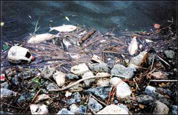
On October 11, 2000, a coal slurry impoundment breached when a mineshaft beneath it collapsed, sending 250 million gallons of molasses-like black muck into Coldwater and Wolf Creeks, tributaries of the Tug Fork. The spill smothered fish, salamanders, large snapping turtles and frogs. As water supplies in four counties dropped below sustenance levels, Kentucky declared an emergency. An EPA official called the spill one of the largest environmental disasters ever in the southeastern U.S.
By late November, cleanup costs had reached $16.5 million. But these efforts, hastily dug ditches and indiscriminate removal of rocks, sediments and riparian vegetation, created a nightmare of their own. The mineral and chemical-laden sludge from this spill will likely rise off the riverbed in the next hard rain, and more than 45 dams are considered at risk of failing. Yet permitting continues, with new dam impoundments still being built.
8. The Snoqualmie
It starts in Washington’s Cascade Mountains as three separate forks and, at the city limits of Snoqualmie, the river’s Snoqualmie Falls cascade in a spectacular, 268-foot drop. Below the falls, the Snoqualmie River moves northwest for about 36 miles to its confluence with the Skykomish River, eventually flowing into Puget Sound. The Snoqualmie watershed plays a large role in the survival of the Sound’s fish stocks, supporting wild runs of coho, chinook, pink and chum salmon along with steelhead and cutthroat trout. The river’s tributaries produce more adult cohos than the entire state of Oregon.
But an unprecedented period of development is taking its toll. Levees and roads cut off access to side channels and tributaries that provide critical rearing and spawning habitat. About 60 percent of the Snoqualmie’s banks have no riparian vegetation left except grass or a buffer that’s only a single tree wide.
Housing has now invaded the Cascade foothills on the eastern side of King County. Some of the large timber companies, such as Weyerhaeuser, have found it more profitable to sell their forest land for large-lot residential developments rather than manage it for harvest. The result has been a series of massive, permanent clearcuts for houses and roads—contributing to flooding and water quality violations as well as fish kills in nearby Snoqualmie tributaries.
A voluntary assembly of local governments, Native American tribes, environmental and business coalitions—known as the Tri-County Response Effort—has joined together to develop a recovery plan for endangered salmon. But while the National Marine Fisheries Service has found that group’s current effort inadequate, so far it’s been unwilling to take steps to strengthen it.
9. The Animas
From its headwaters in the San Juan Mountains of southwestern Colorado, this is one of the West’s few remaining free-flowing rivers. As the Animas moves through the town of Durango, it drops an average of 24 feet per mile, offering adrenaline-pumping rides for a rafting industry that attracts thousands of tourists each year. The river’s Gold Medal trout fishery is the only one existing in the area. Currently unfettered by any major dams or diversions (although it’s used to supply both valley agriculture and some municipal water), the Animas” water quality is considered generally good.

This could all change rapidly should the Animas-La Plata Project be allowed to go forward. First proposed in 1968 as a large irrigation project, then shelved due to high costs and environmental impacts, a scaled-back version was introduced in Congress last year. At an initial cost of $290 million, it would pump water 500 feet up a mountainside for storage in a reservoir. While slated to provide increased water supply to the Ute peoples, the site is in fact more than 10 miles from the nearest tribal land, and the water is primarily destined for irrigation purposes of non-Indian farmers.
Biological assessments by the state’s Bureau of Recreation indicate that 2,000 acres of the 7,000-acre Bodo Wildlife Refuge—home of the state’s second-largest elk herd—would be inundated by the shallow reservoir. Stream flows and key fish habitat for endangered species such as the Colorado pike minnow and razorback sucker will be significantly impacted. The project will likely devastate the trout fishery, severely impact the whitewater industry, degrade air and water quality due to massive expenditures of electrical power needed to pump the water uphill, and exacerbate uncontrolled growth in the region.
10. The East Fork Lewis
The “Jewel of Southwest Washington,” as The East Fork Lewis is known, is one of the few remaining rivers in the Columbia River Basin that’s unimpeded by dams. It flows out of the Gifford Pinchot National Forest along a 212-square-mile watershed, and it serves as a groundwater recharge area for key aquifers. It is also a spawning and rearing habitat for three threatened salmon species, steelhead and cutthroat trout.

Much of the river passes through private property, where owners have erected unauthorized dikes. Urbanization has removed stream bank protection, creating substantial erosion and sedimentation. During a high water event in 1996, a section of the East Fork was swallowed by gravel pits, the result of extensive mining in the river channel over the past generation. This subsequently altered the river’s course, destroyed 5,000 feet of prime salmon spawning habitat, and formed a maze of warm-water ponds and wide shallow channels where salmon predators flourish.
Yet the owner of these gravel pits has proposed a 4,000-ton-a-day extraction operation only a foot above the 100-year floodplain line. Excavations and ponds 30 feet deep would be forged adjacent to the East Fork, drastically altering ground water and surface water features while releasing more sediments. A water rights transfer application is now before the Washington Department of Ecology, while a habitat Conservation Plan is under review by federal fisheries agencies.
11. The Paine Run
Streams like this one inside Virginia’s Shenandoah National Park are widely known as one of the few places in America with healthy populations of wild brook trout. During the springtime, early summer and fall, the park’s streams are crowded with anglers. The watershed of Paine Run, located on the western flank of the Blue Ridge Mountains, has remained undisturbed by human activity—with one exception, which originates far from its confines.

Acid rain, caused by emissions of sulfur dioxide and nitrogen oxides, plagues mountain streams in the mid-Atlantic region. They are immediately downwind of coal-burning electric plants in the Ohio and Tennessee valleys, and their high elevation makes them extremely susceptible to sulfates and nitrates moving through the atmosphere.
Paine Run is one of the most intensely studied streams of its kind, monitored weekly to evaluate the effects of acid rain on its chemistry. Years of heavy acid precipitation have eroded Paine Run’s buffering capacity to the point where it’s almost gone. In its pristine state, Paine Run held between five and eight species of fish; currently, there are only three (fantail darter, blacknose dace and brook trout).
The latter are fairly acid tolerant, but six percent of Virginia’s brook trout streams now have an average acid neutralizing capacity of zero or less, which means they’re incapable of hosting reproductive populations of the species. Even with a 40 percent reduction in sulfate deposition levels that might be expected from the current Clean Air Act, 48 of the state’s streams, including Paine Run, are anticipated to meet that same fate by 2041.
12. The Hackensack
In one of the most densely populated areas in the U.S., the Hackensack River continues to hold the single-largest concentration of estuarine wetland in northern New Jersey. Its 7,000 wetland acres and 1,500 acres of open water are about one-third of what they once were, but are still a vital stopover for more than 260 species of migrating waterfowl, shore birds and raptors, and they support 54 species of fish.
In the years since the 1972 Clean Water Act ended unregulated dumping, all but one of the Hackensack Meadowlands” 21 commercial landfills have been shut down. Tidal waters have been restored to several dried-out marshes. Recreational boating and fishing have returned to what was formerly a mosquito-breeding wasteland.
Now a Virginia-based developer has proposed building Meadowlands Mills there. This would be the region’s largest shopping complex—$1 billion worth of stores, movie theaters and a hotel, surrounded by parking lots for an estimated 100,000 new cars and trucks. To accommodate this, 465 acres of valuable wetlands would be filled in, the largest fill since the Clean Water Act was passed. Marsh habitat for fish and wildlife would be destroyed, and the metropolitan area’s largest remaining open space would be irreparably fragmented.
An environmental study by the Army Corps finds little threat to the area’s ecology, in sharp contrast to the EPA and USFWS, both of which have urged the Corps to deny a fill permit. Although the EPA can veto such decisions, it has overruled the Corps fewer than a dozen times on the 200,000 permit decisions that have been made in the last two decades. And new EPA Administrator Whitman refused to take a stand on the issue while serving as New Jersey’s governor.
13. The Catawba
Beginning in the Blue Ridge Mountains of North Carolina, the Catawba River flows for 225 miles into Lake Wateree, east of Columbia, South Carolina. The Catawba offers habitat for 50 fish species, 160 bird species and 120 river species. It also supports the world’s largest colony of rare rocky shoals spider lilies. Impounded 11 times during its movement through 14 counties, the river is the drinking water source for major cities such as Charlotte, North Carolina.
Unprecedented growth along the Catawba’s banks is escalating demand for both fresh water and waste disposal. Twelve of 28 communities in North Carolina’s portion of the Catawba basin are expected to be near or beyond their ability to supply enough water within 20 years. Pumps and pipelines simply can’t keep pace with the burgeoning development; the Catawba supports more people than any other state river basin.
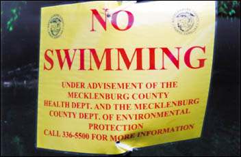
The Catawba already has more than 600 sewage and industrial discharges along its length. In the summer of 2000, at least five substantial raw sewage outflows occurred in the Charlotte area—one lasting several days and totaling 2.7 million gallons caused health officials to close reservoirs to swimming. State regulatory agencies calculated more than nine million gallons of raw sewage illegally discharged over a year-long period.
A proposed new regional wastewater treatment plant near Charlotte would discharge between 80 and 100 million gallons per day into one of the few remaining free-flowing stretches of the river. A massive excavation project would wipe out valuable stands of riparian hardwood forest over a 20-mile stretch, destroying archaeological sites in the floodplain including clay pits from the oldest Native American pottery tradition north of the Rio Grande.
Contacts