


Treading Water
Wetlands Loss Accelerates in Louisiana
In late August and September 2005, the one-two punch of Hurricanes Katrina and Rita battered the Louisiana Gulf coast and obliterated 200 square miles of wetlands. Since the 1930s, the Louisiana coast has lost the equivalent of a football field every 45 minutes.
The Barataria and Terrebonne estuaries, which encompass four million acres of the very richest Louisiana wetlands, produce nearly 20 percent of the nation’s annual seafood catch from mixed salt and fresh water. Louisiana Highway 1 bisects the two estuaries, and leads to Port Fourchon on the edge of the Gulf.
The port services almost a fifth of domestic oil production and 14 percent of the crude oil imported into the U.S. The telephone poles paralleling the road now stand in several feet of water, and low-lying graveyards are relinquishing their dead to the sea. Off the coast, Grand Isle stands as one of the last barrier islands that buffer wetlands from Gulf storms.
George Barisich, president of the United Commercial Fishermen’s Association in Louisiana, has been shrimping and oystering for 40 of his 50 years, and he’s witnessed the acceleration of land to water. He and others have been asking the U.S. Army Corps of Engineers and the state government for years to build a rock jetty to protect the island. "The money they spent on studies alone in the last 30 or 40 years, they could have paid to put the rocks across there," he says. "Or, pump sand from the Gulf, and build your levees."
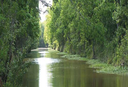
Look at a map of Louisiana and you"ll see the fingers of land that brush the Gulf of Mexico, built up over thousands of years by the rich silt deposits carried by the Mississippi River to its mouth. Over time, the silt compacts and the land sinks, a process called natural subsidence. This ecosystem includes the remaining barrier islands in the Gulf, salt marsh, brackish marsh, freshwater marsh and hardwood forests.
Since the Corps of Engineers first built levees a century ago, 400 million tons of silt a year have been dumped uselessly into deep Gulf waters. And since the 1930s, the oil and gas industry has bulldozed 8,000 miles of canals throughout the wetlands, a process that experts say accounts for about 35 percent of the destruction.

A comprehensive plan to restore the land was drawn up in 1996 by dozens of groups brought together by the Barataria-Terrebonne National Estuary Program (BTNEP). The plan included small water diversions and land-building by piping in sediments from nearby areas. "That allows us to put the sediments where we need them in the shortest period of time," says Kerry St. Pé, BTNEP’s executive director. The plan was approved by both the state of Louisiana and the Environmental Protection Agency (EPA), but little has been implemented.
In 1998, the Corps of Engineers released its Coast 2050 plan, a $14 billion proposal that would have protected or restored almost half a million acres of wetlands in the Barataria basin. But the federal government requested a cheaper $2 billion version, which Congress was considering when the hurricanes struck in 2005.
After that disaster, the state of Louisiana formed the Coastal Protection and Restoration Authority (CPRA), which came up with a new plan last April. Its executive summary states, "[R]estoring sustainability to the coastal landscape is a priority [requiring] diversions of Mississippi and Atchafalaya River water."
These massive freshwater diversions would bring major salinity changes to the wetlands system that St. Pé says will not be acceptable to the diverse stakeholders who supported the BTNEP plan, especially bayou residents.
"It would destroy our way of life," says St. Pé, whose family has lived in the area for seven generations. "You can’t raise oysters, you can’t catch brown shrimp, you can’t catch blue crabs or spotted sea trout in a fresh water system," he says.
In May, the CPRA plan sailed unanimously through both houses of the Louisiana legislature and was approved by then-Governor Kathleen Babineaux Blanco. But taking action awaits the final plan of the U.S. Army Corps of Engineers, due this winter.
Many in coastal Louisiana are unimpressed with the Corps’s track record. Environmentalists, commercial fishers and residents complain that the Corps engages in endless planning but drags its feet on implementation.
The oil and gas industry, which is responsible for much of the wetland destruction, has not offered to help offset the damage. Instead, it supports a public relations campaign."When we started drilling the wetlands back in the "30s or "40s, no one thought they had any value; it was just swamp land," says Larry Wall, spokesman for the Louisiana Mid-Continent Oil and Gas Association. "And people wanted the oil and gas removed. So we used the best technology we had then. From about the 1980s, we quit using pits, we started mitigating canals by filling in one if we built another. And we tried to lessen the footprint of drilling activities."
Restoration advocates acknowledge industry improvements, but say the state and federal governments have let a politically powerful industry off the hook. Meanwhile, they united behind passage of the federal Water Resources Development Act (WRDA), which would have authorized $4 billion for new levees, wetlands restoration and the closing of the Mississippi River Gulf Outlet. WRDA was the first bill to survive a presidential veto and become law last November. In it, dollars for coastal Louisiana were cut to $1.9 billion.